Introduction
For travle 2.0 I decided to try to be much more transparent about how the game works. This page provides some in-depth information about the various countries, borders, connections and rules that govern travle.
Think you've found a mistake? Fill out the feedback form here. Share suggestions or questions on Travle's Official Subreddit: /r/travle_game.
Travle is a Teuteuf Game created by Oisín Carroll.
TL;DR
Why does/n't X connect to Y?
The game is about traveling, not country borders:- Exclaves don't make new borders! You can start or end routes in an exclave*, but you must name every country you'd pass through!
- Bridges and tunnels count for connections.
- You can cross water within a country when there's no other route. This connects the Indonesia to the mainland and Ireland to the UK, but doesn't connect Spain to Morocco
- Corners count! If two regions touch - even just barely - it counts.
Why is X a country?
There are some regions in travle that aren't countries. I think it makes the game more interesting.Can I play more? / How do I get to past games?
The only way to play the daily Travle is to play that day.Try Practice mode!The border for X is wrong!
See below for the map data sources - travle shows borders based on currently-controlled territory, not based on a certain country's view of the world.There's a bug with the scores!
The scoring's a little unintuitive - it's based on the guesses you've made already. If your guess gets you closer to an answer now, you get green. Read below for more info!Mobile App
Travle doesn't have a true mobile app. However, you can add still add link on your home screen.
On Android: Tap the three-dot icon in the top right, then select 'Add to Home screen'.
On IOS: Tap the Share button, then select 'Add to Home Screen'.
Countries & Regions
Overall, travle takes a 'more is more' approach to adding regions...
Indeterminate & Disputed Territories
Travle includes some regions/countries which aren't recognised everywhere and/or have disputed borders. These include:
Åland, Antarctica, British Indian Ocean Territory, Falkland Islands, Hong Kong, Israel, Kosovo, Palestine, Siachen Glacier, Taiwan, Turkish Republic of Northern Cyprus and Western Sahara.
Remote Territories
Travle also splits some countries, especially those with remote territories, into separate regions:| Country | Is treated as the following separate regions |
|---|---|
| Australian Indian Ocean Territories | Christmas Island, Cocos (Keeling) Islands |
| Denmark | Denmark, Greenland |
| France | France, Mayotte, Réunion, Martinique, Guadeloupe, French Guiana |
| Netherlands | Netherlands, Caribbean Netherlands |
| New Zealand | New Zealand, Tokelau |
| Norway | Norway, Jan Mayen, Svalbard |
| Portugal | Madeira, Portugal, Azores |
Map Projection (Why does X look distorted?)
The Travle map uses a map projection which tries to minimize distortion on visible countries. It is much more accurate than a simple mercator map, or even viewing a globe - especially when there is a small part of the globe visible. However, this means countries near the poles may not look how you're used to seeing them on a standard mercator map.
The Travle map uses a geoAzimuthalEquidistant map projection, where the center of the projection is the Geo-Centroid of all currently visible countries.
Country & Region Borders
Travle uses data from Natural Earth, who provide the geojson data used both to generate connections and puzzles, as well as in displaying the game. The method they use to determine country borders may surprise some: Using who currently controls what in the area.
"Natural Earth draws boundaries of sovereign states according to de facto (“in fact”) status rather than de jure (“by law”). We show who actually controls the situation on the ground because it turns out laws vary country to country, and countries are only loosely bound by international law in their dealings with each other. While our de facto policy does not please everyone, it is rigorous and self consistent."
You can read more about their methodology here.
This has some impact on disputed regions, for example Western Sahara is only shown to have territory to the west of the Berm wall, the east of which is currently controlled by Morocco.
Travle makes an exception with Ukraine, which retains Crimea despite the current situation.
Connections
Travle does not treat each country or region as one singular piece, and requires you to make a joined path from Start to End. These rules were voted on by the community, and are a change from Travle 1.0!
Countries and Regions in the game each consist of one or more disjoint Areas. You may pass from one Area to another Area either if:
- (Adjacency): They are adjacent, or a bridge or tunnel connects them OR
- (Island Hopping): They both belong to the same Country or Region, there's only a (relatively small distance of) water between them, which and there's no other route that connects them.
An example of the latter case is Northern Ireland and United Kingdom (Mainland) are two Areas in the United Kingdom. A counterexample would be Kaliningrad Oblast does not connect to Russia's mainland:
The reason for the latter rule is to involve some areas that'd otherwise be impossible to reach; Indonesia and (my home country) Ireland. The other reason is that the game's been played ~5 Million times with these exact connections, and I can't change them now!
You Win when you can pass from Start to End through only connected Areas which are within Countries or Regions you've guessed.
Connections are determined automatically based on adjacent countries from the Natural Earth geojson data. An exhaustive list of examples that affect gameplay are listed below.
Bridges & Tunnels
Travle respects bridges and tunnels which connect countries:
| Countries | Reason |
|---|---|
| France & United Kingdom | Channel Tunnel |
| Denmark & Sweden | The Øresund Bridge and Drogden Tunnel |
| Turkey | Bridges over the Bosphorus |
| Croatia & Montenegro | Croatia's southern tip joins with the mainland with the Pelješac_Bridge, hence shares a border with Montenegro |
Island Hopping
Additionally, Travle allows Island Hopping: Jump across (narrow-ish stretches) of water between parts of the same nation when there's no other route. There are other cases, for example in the south of Chile, which don't create any connections to new countries and are therefore not listed here.
Island hopping is allowed in the following countries or regions:
| Country | Explanation |
|---|---|
| Indonesia | Jump between islands |
| Malaysia | Jump between islands |
| United Kingdom | Northern Ireland connects with the rest of the UK. |
Additionally: Greenland connects to Canada due to their shared ownership of Hans Island. Each can Island Hop to Hans Island, which is a surprising land border between the two countries. See here for more information.
However - Island hopping does not apply to the following countries, which have exclaves accessed via land:
| Country | Explanation |
|---|---|
| Angola | North-west part is disjoint. Angola therefore doesn't connect Congo to Namibia. |
| Azerbaijan | South west is disjoint, Azerbaijan therefore doesn't connect Turkey to Russia. |
| Palestine | Gaza Strip not considered connected to West Bank |
| Russia | Kaliningrad is disjoint. Russia doesn't connect e.g. Poland to [anything mainland russia touches] |
| Spain | Mainland Spain does not connect to Morocco via Ceuta or Melilla (the shortest line narrowly passes nearer Morocco in both cases) |
Surprising Borders or Not-Borders
A short list of surprising edge cases (pun intended).
| Countries | Explanation |
|---|---|
| Morocco and Mauritania | Do not share a border (Western Sahara perfectly divides them). |
| Russia and North Korea | Share a border: See here for more info |
Puzzles & Puzzle Generation
Puzzles for travle are autogenerated based on the connections graph. This first generates all possible routes between countries and their lengths, then picks a sequence of puzzles for the next ~10 years or so according to some rules...
- No two puzzles in the same week can have the same country as a start point, end point, or as a point on any shortest solution (often there are multiple 'shortest' paths or solutions for any given travle).
- The lengths are pseudo-randomized each day to give a good range of difficulty and # guesses.
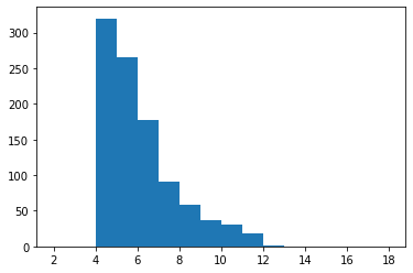
The distribution of puzzle lengths for v2.0 is much more random. You can see the minumum number of guesses to solve the next 1000 puzzles below.
Guess Count
The number of guesses for a Travle is based on the length of the shortest path.
| # Guesses in Shortest Solution | # Extra Guesses |
|---|---|
| 3 | 4 |
| 4-6 | 5 |
| 7-9 | 6 |
| 10-12 | 7 |
| 13+ | 8 |
For example, if the shortest path between two countries requires 6 guesses, the game will give you up to 6+5 = 11 guesses.
Puzzle Scoring
The scoring for Travle is something people often find unintuitive. You don't simply get 🟩/✅ for being on the shortest path: The scoring is based on your previous guesses too. A good guess gets you closer to finishing today's Travle, even if you've already made a detour. Get a Perfect score by guessing the shortest route in order from the Start Country to the End Country.
More specifically... There is always a minimum number of guesses you are from completing a travle. This is what travle uses to determine guess 'quality', and which emoji to give to each guess.
If you make a guess which decreases that number, the guess is marked 🟩. If additionally this guess is connected (via previously guessed countries) to the start country, it's instead marked ✅.
For example, to go from Spain to Austria you can go to France, then via any of Germany, Switzerland or Italy. To start, you're 2 guesses from the answer. If your first guess is Germany, you're now one guess from the answer - so Germany is marked 🟩 (it's not connected to Spain so not ✅). If you then guess Italy - even though that country was on the shortest path to begin with, you're still one guess away. Italy doesn't help you now, so it's marked 🟧 instead.
🟧 means the path through the newly guessed country is a similar length to the shortest path. In the previous example, after guessing Germany you guess Italy. The shortest path is 1 guess. The shortest path which passes through Italy also only requires one additional guess. Hence, it is marked orange. The rule allows a leeway of 1 extra guess too, so even Slovakia would still be marked 🟧 - the path via Slovakia requires 2 additional guesses: France and Poland, which is just 1 more than the shortest path - which only requires France.
🟥 means the path through the newly guessed country is longer than the requirement above, or there isn't a path possible.